Exploring the Evolution of Maps: Navigating the journey through time
As market experts in mapping, Living Map takes the reins to explore the captivating journey of map evolution. With a rich history spanning thousands of years, maps have played a pivotal role in shaping human navigation and exploration. In this blog, we delve into the evolution of maps, tracing their transformative path through the ages.
The historical significance of maps
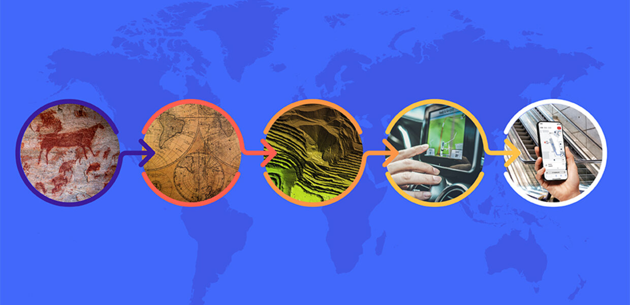
Maps have been an integral part of human history for thousands of years. From the earliest cave paintings depicting hunting grounds to the elaborate cartography of the Age of Exploration, to the precision of modern GPS, maps have evolved in response to technological advancements and societal needs, aiding us to navigate and understand our world. Today, the journey continues as digital maps have become indispensable tools for navigation and wayfinding. Thanks to smart technology, individuals can now effortlessly carry detailed maps on their mobile devices wherever they go, marking a seamless integration of historical relevance with contemporary convenience.
Digital revolution: from paper to pixels
The evolution of maps from paper to digital form can be traced back to the early days of computing. In the 1960s and 1970s, computer scientists began developing software that could create and manipulate images of maps. These early systems were rudimentary by modern standards, but they laid the foundation for the development of modern digital mapping technologies.
GIS and the technological leap
One of the most significant milestones in the evolution of digital maps was the creation of Geographic Information Systems (GIS) in the 1980s. GIS allowed researchers and planners to map complex spatial data and analyse it in ways that were previously impossible. For example, GIS technology allowed scientists to map the spread of diseases, the movement of wildlife, and the patterns of land use and development.
Internet age: online mapping to real-time GPS
With the rise of the internet in the 1990s, digital maps became more widely available to the general public. Companies like MapQuest and Google began offering online mapping services that allowed users to create customised maps and driving directions. These services quickly became popular and paved the way for the development of more advanced mapping technologies.
Aerial and satellite imagery: changing the landscape
The 20th century witnessed a seismic shift with the advent of aerial and satellite imagery, transforming maps into dynamic representations of landscapes. GPS technology emerged, revolutionising outdoor navigation and providing real-time location tracking. However, as urban spaces became more intricate, the need for accurate indoor wayfinding led to the next frontier in map evolution.
Digital maps today
Today, digital maps have become an essential tool for navigation and wayfinding. Smartphones and other mobile devices have made it possible for people to carry detailed maps with them wherever they go.
In addition to providing directions, digital maps have also become a valuable tool for businesses and organisations. Retailers use digital mapping technology to analyse customer data and optimise store locations. Emergency responders use maps to quickly locate accident scenes and direct resources to where they are needed most. Environmental organisations use digital maps to monitor the health of ecosystems and identify areas of conservation concern.
Living Map’s role in the evolving mapping landscape
The evolution of maps from paper to digital form has been a remarkable journey. The development of Smart Technologies and IoT has made Digital mapping technology critical to any digital transformation project. It has transformed the way we navigate and understand our world. As technology continues to advance, we can expect to see even more sophisticated mapping tools that will further revolutionise the way we interact with our environment.
At Living Map, we proudly stand as market leaders by addressing the evolving needs of mapping in today's complex world. Specialising in digital wayfinding and mapping, our company has earned the trust of global clients across various industries. Notable names like Canary Wharf, Star Alliance, and the Met Museum have chosen Living Map to redefine how visitors navigate diverse spaces. The Living Map Platform™ stands as a testament to innovation, offering a turn-key solution that excels in user-friendliness and intuition. It provides real-time, customisable directions for both indoor and outdoor spaces, ensuring clients have full control over their brand and data. Unlike traditional maps, Living Map's platform handles complex routes, adapts to real-time changes, and captures valuable data insights, enhancing operational efficiency for our clients.
As we reflect on the rich history of maps and their transformative journey, Living Map stands at the forefront, guiding the way toward a future where navigation is not just a tool but an experience shaped by precision, user-friendliness, and dynamic adaptability.
Request a demo
Experience the power of our mapping, wayfinding, and asset tracking technology for yourself. See how our software can enhance your facility.