Inclusive Journeys for All

Following on from their successful collaboration on the ADAPT project, Living Map and Open Inclusion were commissioned by SBRI, Innovate UK and SEStran to undertake research into how people with vision, hearing, mobility, cognitive and complex needs plan journeys on public transport, and whether digital solutions could be developed that would improve the solutions available to them in achieving their goals. The commissioning group wanted to develop a door to door planning tool that would help users with disabilities retrieve routing information in a clear way, with alternative travel options and the ability to communicate with staff and other users in case of difficulty.
Open Inclusion ran the qualitative research for this study and collected authentic non-expert user insights from people on their UK-wide research panel of disabled and older participants aged 18 to 75+.
To begin the study, we first sought to understand the challenges users with a range of disabilities face when planning travel and using public transport. We discovered how many used smartphones and to what degree some users changed phone settings to support their needs. We also explored how often they use public transit on familiar or unfamiliar journeys, whether they travelled alone or with companions, and if (and how) they used maps given their access needs. Finally, we investigated what other needs and considerations disabled users had on typical journeys such as noise, crowds and distances (especially when connecting in transit). These were key factors that could add stress to planning and undertaking journeys. Overall we uncovered a whole host of insights that we were able to research further.
Approach
Working closely with Open Inclusion’s panel of disabled and older users, we first ran a qualitative survey with 57 people, discovering that during typical journeys almost half of the disabled respondents (47%) sought help, 48% experienced fatigue and a quarter suffered from anxiety. Other challenges often encountered included poorly trained staff, unclear confirmations of booked assistance, out-of-date accessibility information and bad signposting.
We also asked what might help make journeys easier for disabled travellers. Users told us they wanted to know about changes to their journey such as delays or platform changes (65%), accurate seat availability (56%), step-free routing that was correct (53%), and precise and clear announcements (46%). We discovered that disabled travellers wanted quick and accurate access to important data about user journeys in real-time. The outcome of this research gave us a list of digital product features from which we selected several ideas to explore further.
One of the overriding themes was the lack of up to the minute (or at least very recent) data related to accessibility needs. From routing networks that did not cater to step-free access, by not including dropped kerb data or out of order lifts, to transit network changes not catering to deaf people, such as delays and platform changes only being announced via audio.
We understood from our survey research that users needed an application that responds in real time to their spectrum of needs, be it by allowing colours and text size to be adjusted, audio instructions to be selected in place of written ones, and most importantly providing accurate data for up-to-the-minute notifications.
Our feature research
The team at Living Map focused on the problems likely to have the greatest positive impact and began technical research to understand what was technically feasible and what we could build into our product.
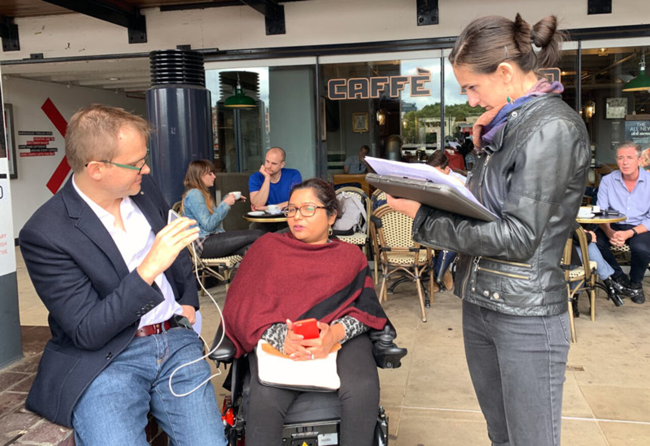
With some of the technical research done, we conducted two further rounds of user research. The first was a focus group where we tested ‘wireframes’ and click-through prototypes to uncover where disabled users expected certain functions to reside in the interface. The second round—which incorporated the insights of the first—involved a smaller set of the same users undertaking a short journey through the streets of London using a simple digital prototype app. This allowed us to further test if our ideas for improved journeys would work in a real-world scenario.
The features we were exploring in detail were:
- Reporting an issue, crowdsourcing missing data (identified from the first stage of the research), such as access restrictions that could be an obstacle for other users as well.
- Directions to destination as text, that could be read by vision-impaired screenreader users or those with spatial difficulties who preferred text to images.
- Show me the ‘nearest’ – quick search options, letting users quickly and easily find important accessible assets on the map.
- Street view for my location, letting users visually check that they were in the right place by cross-referencing digital images of the street with their current view.
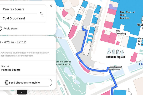
During the user testing, we discovered further insights, such as how some third party mapping applications obscure road labels when providing directions (with their blue line route to the destination), and that users with low vision often struggle to see landmarks on the map, making it hard to triangulate their position. Because our map was created for pedestrians, the blue line followed the pavement, not the road, letting users read the road name. We also discovered many users wanted those road names included in the text directions, i.e. “Turn right onto Hatfields”—valuable insights for our product roadmap.
Our map design performed well, with all journey testers stating that it was much easier to see the map details on our app compared to the maps on Apple or Google Maps. Our standard colour scheme increased colour contrast more than other similar map apps did. One user with significantly reduced eyesight said our app was the best map he had used on his smartphone.
The results from the journey tests were very encouraging. Participants rated the prototype highly, with ‘ease of use’ scores between 3.5 and 4.5 out of 5. We uncovered concerns with one feature (reporting an issue), which ran contrary to the earlier research, but helped clarify our understanding about when users would be in the right mindset to report problems — a fundamental benefit of doing testing of prototypes in the field with real disabled users. We’ve already taken that learning forward into our designs and roadmap.
The final feature we explored in detail was accessing services that would let us provide street level imagery within our product. The development team researched services currently available, both open source and paid for services, and produced a proof of concept that integrated a service into our interface.
Outcomes
In late 2019 we presented our research findings to the SEStran group in Edinburgh, with a detailed walk-through of the process we followed for the research. The commission was particularly interested in hearing the feedback from actual users, gathered during our two rounds of user testing, and was very pleased with the initial technical research towards the issues raised by the users in the survey.
The outcomes of this project can be grouped into:
- Inclusive user insight
- Technical feasibility research
The user insight delivered highlighted key issues that disabled users with a wide range of access needs face in their daily lives when planning and conducting journeys, whether they include public transport or simply walking to their destination. This helped the development and design team identify the major issues that we could address with the app solution.
The technical research provided an accurate estimate and feedback on the technical feasibility of the features identified by users during the survey, excluding some of the elements that can easily be addressed with the integration with third-party systems, or the ones too difficult to tackle when tying multiple organisations and travel providers together.
We are now awaiting Phase 2 of the project, the actual development of the solution.
Request a demo
Experience the power of our mapping, wayfinding, and navigation technology for yourself. See how our software can enhance the customer experience in your facility.