Living Map Product Highlights: 2025 in Review
Over the past 12 months, the Living Map Product and Development team has delivered a series of updates designed to help organisations manage, understand, and navigate complex spaces more effectively. From smarter asset tracking with Locator Zones to faster performance, enhanced kiosks, and improved analytics, these improvements help teams act faster, improve accessibility, and scale with confidence.
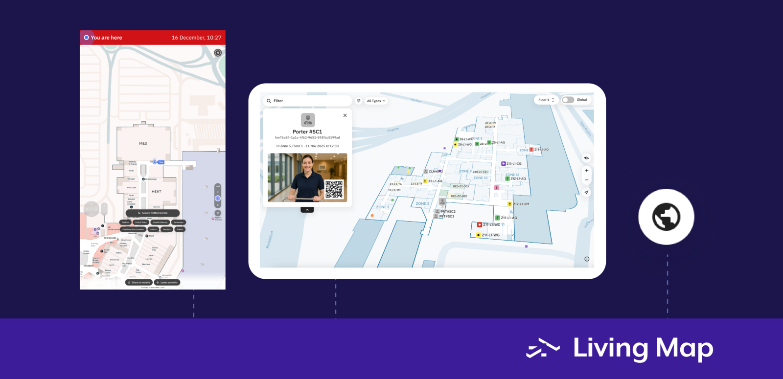
Smarter Asset Tracking with Locator Zones
What are Locator Zones?
This year, we introduced Zones to our Locator asset tracking and visualisation platform — a major step forward in making spatial data more meaningful and actionable. Zones allow teams to define fixed areas on a map and instantly visualise live conditions within those spaces.
Zones can highlight environmental changes in real time. For example, they can be used to monitor humidity in storage areas housing sensitive assets, or flag when meeting rooms exceed comfortable temperature thresholds.
We also introduced full historical tracking, enabling teams to review trends over days, weeks, or months. This makes it easier to identify patterns, optimise environments, and make informed, data-backed decisions.
Faster Navigation with Search Tags
Quick access to what matters most
Search Tags are a simple but powerful way to create quick-access filters for fully customisable collections of points of interest (POIs) on your map.
Whether you need to surface EV chargers, first-aid stations, or amenities, Search Tags help users find what they need in a single tap. This is especially valuable in large or complex spaces, where reducing friction improves both user experience and operational efficiency.
Improved Analytics and Reporting Infrastructure
Behind the scenes, we completed a major upgrade to our analytics infrastructure. Map and kiosk analytics are now supported by a time-series optimised database, resulting in faster queries, smoother dashboards, and improved scalability as usage grows.
This upgrade lays the foundation for richer reporting and more advanced insight tools in future releases.
Multi-Language Support for Wayfinding Kiosks
Our wayfinding kiosks now support multi-language functionality, matching the capabilities of our web maps. Visitors can switch languages instantly, making navigation more accessible to international audiences and diverse communities.
This update helps organisations improve inclusivity while delivering a more intuitive visitor experience.
Performance Improvements Across the Platform
We’ve significantly improved performance across our web applications. Assets are now served from locations geographically closer to users, resulting in faster load times and a smoother overall experience.
We’re also continuing to optimise routing and search performance, ensuring that using Living Map feels faster and more responsive than ever.
What’s Next for Living Map?
These updates reflect our ongoing commitment to building smarter, more accessible digital mapping solutions. With further enhancements already planned as part of our 2026 product roadmap, we’re only getting started.
Want to learn more about our digital wayfinding and asset tracking technology? Chat to our team.
FAQs
What is digital wayfinding?
Digital wayfinding uses interactive maps to help people navigate complex spaces such as hospitals, shopping centres, transport hubs, and campuses. It guides users step by step to their destination, reducing confusion and improving overall visitor experience.
How does asset tracking work with Living Map?
Living Map visualises asset data directly on a digital map, allowing teams to see where equipment is located and monitor conditions in real time. Features like Locator Zones and historical tracking help organisations manage assets more efficiently and make data-driven decisions.
How do these updates improve accessibility?
Multi-language kiosks, clearer navigation tools, and faster performance make it easier for people of all abilities and backgrounds to navigate complex spaces independently, reducing reliance on staff and improving inclusivity.
Request a demo
Experience the power of our mapping, wayfinding, and asset tracking technology for yourself. See how our software can enhance your facility.